Interactive map shows flooding risk as Gulf rises and southern Louisiana continues to sink | The Lens
The state has created an interactive, online map providing a realistic look at the future, which probably will be more shocking to residents than the words in the new Coastal Master Plan it is based on.
FLOOD RISK UNDER LOW GREENHOUSE-GAS SCENARIO

Coastal Protection and Restoration Authority
This map shows the flood risk under the state’s scenario if increases in greenhouse gas emissions are held to a relatively low level. Purple areas would see at least 16 feet of flooding in a 100-year storm; teal would have 13 to 15 feet; dark green would have 10 to 12 feet; light green would have 7 to 9 feet; yellow would see 4 to 6 feet; orange would see 1 to 3 feet.
FLOOD RISK UNDER HIGH GREENHOUSE-GAS SCENARIO

Coastal Protection and Restoration Authority
This map shows the flood risk under the state’s scenario if greenhouse gas emissions are not brought under control, causing sea levels to rise more. In a 100-year storm, much more of the coast would see flooding of at least 16 feet (shown in purple). Areas in teal would have 13 to 15 feet of flooding; dark green would have 10 to 12 feet; light green would have 7 to 9 feet; yellow would see 4 to 6 feet; orange would see 1 to 3 feet.
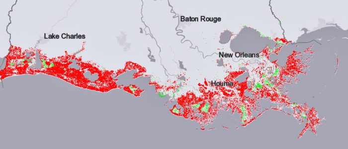
PROJECTED LAND LOSS WITH COASTAL RESTORATION AND LOW EMISSIONS

Coastal Protection and Restoration Authority
Red shows where land would be lost and green shows where it would be gained in 50 years if greenhouse gas emissions are controlled and the coastal restoration plan accomplishes its goals.
PROJECTED LAND LOSS WITH COASTAL RESTORATION AND HIGH EMISSIONS

Coastal Protection and Restoration Authority
Under this scenario — if greenhouse gas emissions are not controlled, but the state accomplishes its coastal restoration goals — more land would be lost in 50 years.
PROJECTED LAND LOSS WITHOUT COASTAL RESTORATION AND HIGH EMISSIONS

Coastal Protection and Restoration Authority / Coastal protection and Restoration Authority
This is the worst of the state’s projections, showing widespread land loss. This is what would happen if greenhouse gas emissions are not controlled, which would cause relatively high sea level rise, and the state does nothing more to rebuild and protect the coast.