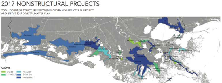
The 2017 draft version of the Coastal Master Plan, released today, offers a much grimmer view of the future than its predecessors. Twice as much land could be lost if the state does nothing. Even if everything works as planned, about 27,000 buildings may have to be elevated, flood-proofed or bought out, including about 5,900 in St. Tammany.
For 10 years, Louisiana’s Coastal Master Plan has represented the state’s vision for preventing its bottom third from being consumed by the Gulf of Mexico.
It predicts that even if everything works as planned, 2,800 square miles of coast still could be lost in the next four decades, and about 27,000 buildings may need to be floodproofed, elevated or bought out, including about 10,000 in communities around New Orleans. That’s under the plan’s new worst-case scenario for sea level rise and subsidence.
About 5,900 of those are in St. Tammany, including Mandeville, Covington and Slidell. That includes about 900 that may need to be bought out.
The new plan also has dropped the long-held claim that the state would be building more land than it’s losing by 2065.
Scientists in charge of the Coastal Master Plan said the more dire outlook can be traced to one striking fact: The worst-case scenario for human-caused sea level rise in the 2012 plan, 1.48 feet, has become the best-case scenario in the 2017 edition. In fact, the National Climate Assessment now estimates sea levels on U.S. coastlines could rise 4 feet by 2100.
“When we put those forecasts into the models, there’s less we can accomplish,” said Bren Haase, head of planning and research at the state Coastal Protection and Restoration Authority.
The new worst-case scenario projects that 4,000 square miles would be lost if the state stops all efforts to restore its crumbling, sinking coastal landscape. That’s double the loss projected in the same scenario in the 2012 plan.
However, the latest plan retains hope of restoring 800 to 1,200 square miles of wetlands and beefing up protection against hurricane storm surges with levees and floodwalls.
A CHANGING PLAN IN THE FACE OF DARKENING SKIES
The master plan was conceived in 2007 after Hurricane Katrina raised awareness of the vital role coastal wetlands can play in storm surge protection. The plan is updated every five years to reflect evolving science on how to address the two ongoing changes to the landscape: sinking of the sediment-starved deltas and rising sea level due to climate change.
Each plan is constructed by coastal scientists and engineers from the state and an array of federal agencies, with input from a wide range of stakeholders, such as the shipping and fishing industries.
The 2017 draft plan incorporates that input and is now out for review by the general public.
Each plan must be approved by the Legislature, but lawmakers cannot amend it; they can only vote it up or down. They unanimously approved the versions in 2007 and 2012.
The original price tag was $50 billion, but the current cost is about $92 billion after accounting for inflation, according to a study by Tulane University. Current funding can carry the plan forward for another 10 years.